Sydney, Australia
September 1, 2004
Print Version
VizMAP, Pty Ltd will present an interactive 3D visualization of the Surat Energy Province in Queensland, Australia using TerraSim’s TerraTours real-time 3D viewer, at the World Energy Congress September 5 – September 9 in Sydney, Australia. The Surat visualization is a focal point in the exhibit of the Australian Federal Government’s Invest Australia initiative.
The Surat Energy Province holds many undeveloped energy resources, which Invest Australia and the Queensland Government are working towards developing. VizMAP delivered three contiguous TerraTours visualizations of the Surat Energy Province, an area of 450km by 350km, to the Queensland Government, commissioned by the Queensland Department of Natural Resources and Mines. A fourth high-resolution TerraTours visualization was delivered which highlighted the Moura Mine.
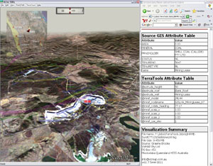
The three contiguous visualizations are based on Landsat 7 imagery that was orthorectified, color-matched and mosaiced, as well as a Geosciences Australia DEM of the area. The fourth visualization, concentrating on Moura Mine, was based on aerial photography of the mine and topographic detail collected on the ground by surveyors at the mine. VizMAP constructed the visualizations using TerraSim’s database construction product, TerraTools® , and GISLink™ which compiled the information-rich linked 3D visualization. Once compiled, the TerraTours query capability provided interactive access to web sites, photos, movies, site plans and maps, and other GIS attributes relevant to the area. Coal basin extents, petroleum leases, mining leases, coal resource layers and mineral development licenses were set apart by color-coded GIS polygon "walls".
The Queensland Department of Natural Resources and Mines expects the Surat Energy Province project to attract significant attention at the World Energy Congress and is a wonderful example of how TerraTools and TerraTours can be used for 3D information visualization.
For more information on the Surat Energy Province visualization, please contact Mr. Graeme Brooke of VizMAP Pty. LTD.
|
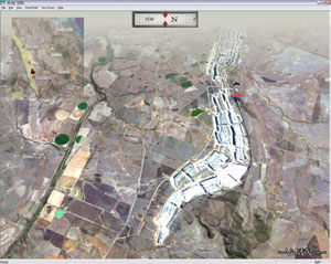
Moura Open-Cut Coal Mine 140km SW of Gladstone (Landsat 7 imagery) delivers 6 million tons of metallurgical coal per annum. |
|
Callide Coal Mine 120km SW of Gladstone (Landsat 7 imagery) delivers 10.5 million tons of medium ash sub-bituminous thermal coal per annum. |
|
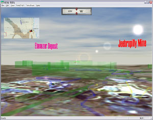
This shows Jeebropilly and Ebenezer, 90 km WSW of Brisbane at the eastern edge of the Surat Coal Basin. The green transparent fences are TerraTours queriable Mineral Development Licenses. The yellow fences are Mining Leases. The blue fences represent the Coal Resource Layer. The purple fences represent the Coal Basin Extents and the red fences are Petroleum Leases. |
|
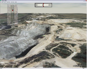
Moura Open-Cut Coal Mine 140km SW of Gladstone (aerial photography) delivers 6 million tons of metallurgical coal and thermal coal per annum. |


