| About VizMAP
VizMAP Pty Ltd, is a leading supplier of terrain Visualisation and related services to the defence, GIS, environmental, mapping, mining and exploration industries, engineering and construction firms, developers and planners, as well as government administration departments dealing with land, transportation and the environment.
VizMAP‘s products are designed to be run on reasonably to highly configured graphics computers (PC, Linux and Unix) for public display, group training, mission rehearsal, environmental monitoring, etc. and to enhance management decision making.
VizMAP is headquartered on Queensland’s Sunshine Coast (Australia) with affiliation in Asia, Europe, Africa and the USA and thereby provides support and services to customers worldwide.
If you need to visualise anything geographic, e-mail VizMAP here with the details.
For more information about VizMAP visit the VizMAP Web site at http://www.vizmap.com.au.
|
VirtualGeography
Subscription
Details
To subscribe to VirtualGeography,
click here.
To unsubscribe to VirtualGeography,
click here.
|
A Moment’s Notice
If at first you don’t succeed, skydiving is not for you. — Anonymous  |
|
VirtualGeography – the newsletter
|
| G’Day… and Welcome to VirtualGeography |
from VizMAP |
| Welcome to another free VirtualGeography from VizMAP Pty Ltd.
VirtualGeography is a collection of interesting snippets from all over the shop, dealing with industry issues concerning the computer based visualisation of geography and a few other associated (or otherwise) interesting bits and pieces. You are receiving this either because you subscribed to VirtualGeography or you have had recent dealings with VizMAP Pty Ltd. If you do not wish to receive further instalments of VirtualGeography, just click on the unsubscribe link at the bottom of this e-mail.
A new VirtualGeography is pushed out about once per month, towards the end of the month, which shouldn’t be too big a drain on your mailbox if you’re not already subscribed (of course it won’t be a drain on your mailbox if you ARE subscribed, either  ). If you know of anyone who might like to get VirtualGeography, feel free to forward this to them and ask them to subscribe. By the way, subscription and unsubscription details are at the bottom (click here). ). If you know of anyone who might like to get VirtualGeography, feel free to forward this to them and ask them to subscribe. By the way, subscription and unsubscription details are at the bottom (click here).
So, g’day to all you enthusiasts requiring to visualise and simulate both urban and rural geographic information (GIS), cartography, photogrammetry, remote sensing, digital elevation modelling (DEM) and general mapping.
|
By the spelling of "Visualisation" you may have already guessed that we’re not US based – that’s a good thing, or at least not a bad thing. This comes to you from Mooloolaba on the Sunshine Coast of Queensland, Australia, where it’s beautiful one day and perfect the next.
The link between visualisation and mapping may seem a little esoteric if this is your first encounter with this sort of stuff, but let me tell you, the bond is significant… but enough of that: on with the show… I hope you like it. Any feedback you might have is highly appreciated. E-mail me here to make your comments.
Enjoy…
Graeme Brooke
VizMAP Pty Ltd
|
 |
P.S. You’ll need an active internet connection to view any images that are in the content. We’ve done it this way to keep the size of the e-mail to a minimum.
|
| |
Back to Top |
| The Industry’s Two Cents Worth… |
| Virtual Heritage |
from About 3D Graphics |
| Have you ever wondered what the Colossus of Rhodes really looked like, or wished you could have strolled through the Hanging Gardens of Babylon? Sadder still, did you miss your chance to visit the Bamiyan Buddhas in Afghanistan or the World Trade Center in New York, both now destroyed?
In the future, you may not have to worry about missing out on these wonderful sights. There are a number of groups utilizing virtual reality to insure that soon everyone will have a chance to visit the wonders of our world, both past and present. Working under the label of Virtual Heritage, these groups and their projects have become increasingly important in the conservation, preservation, and interpretation of our world’s cultural and natural history. Virtual reality technology is also solving one of the largest issues concerning present-day cultural heritage assets; how to allow the public access to important historical sites without the destruction that accompanies hoards of tourists
Re-creations of culture heritage structures are done for many reasons. For instance, The Museum of the Terra Cotta Warriors and Horses in China is using a laser range finder to document the fragile terra cotta statues before they are unearthed. Since the very act of digging these artworks out of the ground causes damage no matter how carefully it is done, this method allows scientist to discover important aspects of the relics such as the original color of the statues which has now leeched into the surrounding clay. Many of these relics were also broken in ancient times and the virtual models allow scientists to ‘pick up and move’ the virtual pieces allowing reconstruction without any additional damage to the still buried statues. This also allows most of the relics to be left where they are for future generations of scientists who may have better tools.
|
| Read that full story here |
Back to Top |
| Hardcore Stuff (hardware bits)… |
| Intel’s Digital Home Vision Moves Closer To Reality With New Industry Enabling Building Blocks |
from Intel |
Engineering Platforms and UPnP* Tools Aid Delivery of Digital Media Throughout the Home
INTEL DEVELOPER FORUM, SAN JOSE, Calif., Feb. 19, 2003 – Intel Corporation announced new industry building blocks that bring the vision of the Digital Home closer to reality. Available immediately are Digital Home reference and concept platforms, and ten powerful UPnP* tools that underscore Intel’s support of the Digital Home vision.
"We know that consumers are readily anticipating the day when PCs and consumer electronics work together easily and reliably," said Louis Burns, vice president and co-general manager, Intel Desktop Platforms Group. "People want to be able to move their digital media content effortlessly between PCs and CE devices for maximum flexibility and enjoyment. And they’re looking to Intel to make it happen. By providing the developer community with these enabling tools, developers will be able to design and build PCs that easily and seamlessly distribute digital media throughout the home."
The "Statesboro" reference platform will assist OEMs and motherboard makers to develop new PC systems this year that broadcast digital photos and music to TVs and stereos throughout the consumer’s home. Statesboro is an implementation tool designed for developers that showcases the 2003 Digital Home vision. The reference platform is a complete, validated system solution featuring key technologies in support of the Digital Home usage models, as described in the Desktop Platform Vision Guide for 2003. These technologies include: Intel® 3.06GHz Pentium® 4 Processor with Hyper-Threading Technology 1, "Springdale" chipset, Dualband 802.11 Wireless NIC, Serial ATA Hard Disk Drive, Dual Channel DDR Memory, and a DVD/CD-RW Optical Disk Drive.
The new concept platform, codenamed "Powersville", showcases additional levels of Digital Home experiences, such as wireless streaming video and personal video recording, which consumers can expect as included PC features in the 2004 time frame. Powersville is designed to provide an early demonstration of experiences and technologies in order to highlight innovation opportunities for the PC industry.
|
| Read that full story here |
Back to Top |
| Softcore Stuff (software and data bits)… |
| ‘Microsoft Flight Simulator: A Century of Flight’ Commemorates 100 Years of Aviation History |
from National Centre for Simulation |
| As the world prepares to celebrate the 100th anniversary of powered flight, Microsoft Corp. announced that "Microsoft(R) Flight Simulator: A Century of Flight" is in development and cleared for takeoff this July.
With "Microsoft Flight Simulator: A Century of Flight," the next milestone in the award-winning "Flight Simulator" franchise, Microsoft celebrates 20 years of developing and perfecting computer flight simulation. "A Century of Flight" allows aviation enthusiasts to experience history at the controls of historic aircraft, such as Charles Lindbergh’s Ryan NYP "Spirit of St. Louis," the Douglas DC-3 and the world’s first successful powered aircraft, the Wright Flyer.
New engaging features such as interactive multimedia provide a wealth of historical information on the planes that shaped aviation history and the pilots who flew them. Informed and insightful articles explain all there is to know about Microsoft’s "Flight Simulator" and the 24 aircraft included in the software. "Microsoft Flight Simulator: A Century of Flight" also introduces an updated, dynamic weather system, enhanced automatically generated scenery (AutoGen) and detailed visual effects, improved Air Traffic Control functions, and 3-D interactive cockpits, as well as 15 modern aircraft, including the Boeing 777, the Beechcraft Baron and the Robinson R22 helicopter.
"Launching ‘A Century of Flight’ in conjunction with a historical milestone as monumental as the invention of powered flight is an exhilarating, once-in-a-lifetime experience for all of us on the ‘Flight Simulator’ team," said Bruce Williams, product planner at Microsoft Aces Studios. "There are a lot of organizations celebrating the centennial of flight, but ‘Century of Flight’ empowers people to get into the cockpit of legendary aircraft such as the Wright Flyer and the ‘Spirit of St. Louis’ to feel what it was like to actually fly those planes."
|
| Read that full story here |
Back to Top |
| Sunshine Coast Marine Life Rescue Centre |
from VizMAP |
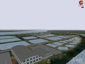
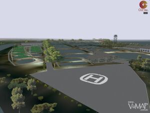
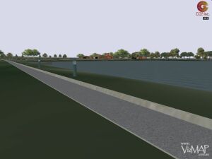
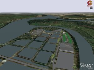
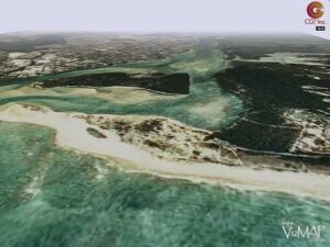
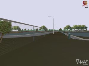
| VizMAP recently created a Vis-Sim database for the proposed Marine Life Rescue Centre to built on Queensland’s Sunshine Coast. The Marine Life Rescue Centre will incorporate a Search and Recovery Division and is adjacent to one of the two Barramundi farms in the region. Each of these three facilities was included in the virtual environment created by VizMAP.
Sample still images from the completed dynamic visualisation database are displayed here. An active internet connection is required to be able to view these scenes.
Click on these small resampled images to view the full screen images on the VizMAP website. Bear in mind that these are just screen dumps from a dynamic, interactive, 3D "flythrough".
|
| If you have a need to dynamically visualise your geographic data, let VizMAP know your requirements… |
Back to Top |
| New game ‘There’ puts you there |
from CNN |
MENLO PARK, California (AP) — It was the dream of many a dead dot-com: build a virtual universe where people can socialize without the confusion of chat rooms or the awkwardness and emotional investment of physical face-to-face encounters.
Backed by serious venture capital and sophisticated software, There Inc. is hoping to offer just that, and is betting that people will be happy to pull out their credit cards to buy virtual clothes, good looks — even a trusted canine companion.
Without recent advances in personal computer technology, the lush graphics of There’s online universe would not be possible. In order to participate, many people would need to upgrade their home PCs.
Facing competition
The company, in secret development for four years, faces competition meanwhile from online games. On the surface at least, a newly launched Internet version of the popular Sims franchise resembles There.
"The difference is Sims online is essentially a game. There is not," said Tom Melcher, There’s chief executive. "There is a place. In Sims, you’re driven by game motives. You have hunger, comfort, a bladder and energy. In There, you’re driven by relationships."
The There universe was being unveiled for initial beta testers Wednesday at the Consumer Electronics Show in Las Vegas. It officially launches later this year.
By downplaying competition, There hopes to attract women to its universe, which is roamed much like the legendary computer game Myst. In fact, some areas look and sound like the mythical Myst island with the constant chirping of birds and distant roar of surf.
"If we can build a product that women love, guys will show up," Melcher said. "The reverse is not true."
Existing, then logging off
Unlike Myst — which was eerily absent of other people — fellow humans, or online incarnations called avatars, are present to chat and play with. There’s also no sequence, or "end of game." People just exist — until they log off.
Conversation appears as cartoon balloons that float above participants’ heads. Voice chat also is possible if the Internet connection is fast enough.
People can buy clothes from partners like Nike, Levi Strauss & Co. and in auctions by other users with There’s very own currency.
Some "Therebucks" will be included in the monthly fee — expected to be about $10. Users also can purchase additional "Therebucks" with a credit card or earn them by creating activities.
The rates are expected to fluctuate as testing proceeds, though $1 now buys 1,787 Therebucks or about one-sixth of the price of a virtual dog — available in two breeds — or a buggy.
Roaming islands, planets
With transportation such as buggy or hoverboard, players can roam various islands or even planned Planets, each with its own themes. An online newsletter will detail activities so users aren’t lost in what could become a very large electronic space.
The notion of buying virtual props isn’t new. Sony’s online medieval role-playing game EverQuest has its own underground economy in which players buy gear with real money outside the game, on eBay for instance, rather than earn it by playing.
There Inc. executives say their program, available online and with the purchase of some video cards, can run on most modern home computers that have a processor speed of at least 800 megahertz and a modern graphics card.
The company is looking for mainstream customers but they’re not likely to want to take apart their PC to add a better graphics card, said Joe Laszlo, a senior analyst at Jupiter Research.
There works on a dialup connection to the Internet, though a high-speed connection brings additional features.
The company, which has secured $33 million in funding through venture capitalists and 84 employees, says it can break even with just 150,000 subscribers. Executives say they have enough funds to last two years. |
| Read that full story here |
Back to Top |
| Whazzup Next – with 20/20 Foresight… |
Stuff to look out for in March, April & May
| Legend |
| Included in last issue… |
| Updated since last issue… |
| New since last issue… |
|
This calendar of events has been collated from:
|
| Mar, 2003 |
| 28 Feb – 1st Mar |
IMTA (EAME) Tenth Annual Conference and Trade Show |
Budapest, Hungary |
| 1 Mar, 2003 |
Avenza Systems Training |
Budapest, Hungary |
| 1 Mar, 2003 |
Introduction to MAPublisher workshop at IMTA Europe |
Budapest, Hungary |
| 1-4 Mar, 2003 |
Extend 2003 – SRC’s Annual User and Partner Conference |
Broomfield, CO, USA |
| 1-5 Mar, 2003 |
California/Hawaii/Nevada/Guam-ESRI Regional Users’ Group |
Honolulu, Hawaii USA |
| 1-5 Mar, 2003 |
Workshop on Remote Sensing: "Innovatory methodologies for satellite image Processing and analysis" |
Manama, BAHRAIN |
| 2-5 Mar, 2003 |
The Geospatial Information & Technology Association’s (GITA) Annual Conference |
San Antonio, Texas, USA |
| 3-4 Mar, 2003 |
Regional Airline Training Conference and Tradeshow, RATS 2003 |
Orlando, FL USA |
| 3-4 Mar, 2003 |
The 2nd International TD-SCDMA Summit 2003 |
Beijing, China |
| 3-5 Mar, 2003 |
Public Wireless Hotspots |
London, UK |
| 4-6 Mar, 2003 |
GEO-evenement 2003 |
Paris, France |
| 4-6 Mar, 2003 |
The International Direct Marketing Fair |
Earls Court 2, London UK |
| 4-8 Mar, 2003 |
99th Annual AAG 2003 Meeting |
New Orleans, LA USA |
| 6 Mar, 2003 |
Migrating Coverages to the Geodatabase |
Oklahoma City, Oklahoma USA |
| 6-7 Mar, 2003 |
Avenza Systems Training – MAPublisher training Sessions |
San Antonio, TX USA |
| 6-7 Mar, 2003 |
FME Training |
Houston, Texas USA |
| 6-7 Mar, 2003 |
MMS China |
Beijing, China |
| 6-7 Mar, 2003 |
Workshop on Internet Usage over 2,5G and 3G WIU253 |
Barcelona, Spain |
| 10-13 Mar, 2003 |
Herbert Resource Information Centre (HRIC) User Group conference |
Ingham, Queensland, Australia |
| 12-13 Mar, 2003 |
Geo-statistical Analysis of Spatial Data |
Ann Arbor, Michigan, USA |
| 12-13 Mar, 2003 |
Telematics Asia Pacific |
Seoul, Korea |
| 12-14 Mar, 2003 |
CEOS/NASDA Symposium on "Space Platforms for Water and Climate" |
Awaji Island, JAPAN |
| 13-14 Mar, 2003 |
Introduction to Disease Clustering and Spatial Epidemiology |
Ann Arbor, Michigan, USA |
| 16-19 Mar, 2003 |
GeoTec Event |
Vancouver, British Columbia, Canada |
| 16-19 Mar, 2003 |
GIS-T 2003: The Evolving Frontier |
Colorado Springs, CO, USA |
| 16-19 Mar, 2003 |
IndusWorld 2003 |
Las Vegas, NV USA |
| 16-21 Mar, 2003 |
IEEE Wireless Communications and Networking Conference |
New Orleans, Louisiana USA |
| 17 Mar, 2003 |
Safe Software Product Parade and HelpDesk |
Vancouver, British Columbia
Canada |
| 17-18 Mar, 2003 |
Tennessee Geographic Information Council |
Nashville, TN USA |
| 17-19 Mar, 2003 |
CTIA WIRELESS 2003 |
New Orleans, LA USA |
| 17-19 Mar, 2003 |
GIS-T |
Colorado Springs, CO USA |
| 17-21 Mar, 2003 |
34th Annual Lunar & Planetary Science Conference |
Houston, TX USA |
| 18 Mar, 2003 |
GEONorth 2003 |
Manchester, UK |
| 18 Mar, 2003 |
Galileo Industry Day |
Brussels, Belgium |
| 18-19 Mar, 2003 |
The 2nd Annual Summit Asia Pacific WiFi 2003 |
Hong Kong, China |
| 18-21 Mar, 2003 |
Microsoft Mobility Developer Conference |
New Orleans, LA, USA |
| 19-20 Mar, 2003 |
2nd International Symposium on Spatial Data Quality |
Hong Kong, China |
| 19-20 Mar, 2003 |
The Retail Sector in Russia & the CIS |
Moscow, Russia |
| 19-20 Mar, 2003 |
FME Training |
Birmingham, UK |
| 19-28 Mar, 2003 |
Bentley Microstation v8 Roadshow |
Worldwide |
| 20 Mar, 2003 |
Radius Topology Web Forum – Laser-Scan |
USA – free web forum with experts to talk to online. 10 GMT |
| 20-21 Mar, 2003 |
FME Training |
Vancouver, BC |
| 22 Mar, 2003 |
ISPRS WG IV/9 ET Mapping Workshop "Advances in Planetary Mapping 2003" |
Houston, TX USA |
| 22-25 Mar, 2003 |
ESRI Worldwide Business Partner Conference |
Palm Springs, CA USA |
| 23-27 Mar, 2003 |
United Nations/European Space Agency Workshop on Remote Sensing Applications and Education |
Damascus, SYRIA |
| 24-26 Mar, 2003 |
Munich Satellite Navigation Summit2003 |
Munich, Germany |
| 24-26 Mar, 2003 |
Missouri GIS Conference |
Columbia, Missouri, USA |
| 24-28 Mar, 2003 |
SD West 2003 |
Santa Clara, CA |
| 25 Mar, 2003 |
Migrating Coverages to the Geodatabase |
Austin, Texas USA |
| 25-28 Mar, 2003 |
Workshop "New Developments in Close Range Photogrammetry" |
Bonn, GERMANY |
| 26 Mar, 2003 |
Migrating Coverages to the Geodatabase |
Stamford, Connecticut USA |
| 26 Mar, 2003 |
Newtech Conference |
Ballarat, Victoria, Australia |
| 26-27 Mar, 2003 |
Jill Dando Institute National Crime Mapping Conference |
London, UK |
| 27 Mar, 2003 |
Migrating Coverages to the Geodatabase |
Charlotte, North Carolina USA |
| 27 Mar, 2003 |
Migrating Coverages to the Geodatabase |
Dallas, Texas |
| 27 Mar, 2003 |
7th Annual Northeast Oregon Geographic Information System User Conference |
Pendleton, OR USA |
| 27-28 Mar, 2003 |
Mobile Enterprises 2003 |
Singapore |
| 27-28 Mar, 2003 |
Reinsurance claims and collections |
London, UK |
| 28-30 Mar, 2003 |
NSGIC 2003 Mid-Year Conference |
Denver, Colorado USA |
| 29 Mar – 2 Apr, 2003 |
ACSM 2003 |
Phoenix, Arizona, USA |
| 30 Mar – 1 Apr, 2003 |
Platts Global Power Market Conference |
New Orleans, LA USA |
| 30 Mar – 1 Apr, 2003 |
Integrating GIS & CAMA |
Columbus, OH USA |
| 30 Mar – 4 Apr, 2003 |
2003 Spring Simulation Interoperability Workshop (SIW) Focus: Modeling and Simulation in Support of Future Combat Systems |
Kissimmee, FL USA |
| 30 Mar – 4 Apr, 2003 |
Advanced Simulation Technologies Conference (ASTC 2003) |
Kissimmee, FL USA |
| 31 Mar 2003 |
Migrating Coverages to the Geodatabase |
Columbus, Ohio USA |
| 31 Mar – 2 Apr 2003 |
Int. Conference towards an operational system for monitoring, modeling, and forecasting of phenological changes and their socio-economic impacts "Challenging Times" |
Wageningen,
The Netherlands |
| 31 Mar – 1 Apr 2003 |
The Premier 2003 Mobile Open Services Access (OSA) Forum |
Singapore |
| 31 Mar – 4 Apr 2003 |
3rd Annual Polish Private Equity & Venture Capital Forum |
Warsaw, Poland |
| 31 Mar – 4 Apr 2003 |
Spring 2003 Location Based Services Summit |
San Jose, CA USA |
| Apr, 2003 |
| 1-3 Apr 2003 |
3rd International Conference on Computer Vision Systems "ICVS’03" ISPRS Comm.III |
Graz, Austria |
| 2-3 Apr 2003 |
BAPCO 2003, The Public Safety Communications and IT Event |
London, UK |
| 2-3 Apr 2003 |
APAS (Association of Public Authority Surveyors ) Conference |
Wollongong, NSW Australia |
| 2-4 Apr 2003 |
PikeNet Forum |
Chicago, IL USA |
| 5-10 Apr 2003 |
XI Brazilian Remote Sensing Symposium "XI SBSR" |
Belo Horizonte, Brazil |
| 6-11 Apr 2003 |
EGS-AGU-EUG 2003 Joint Assembly |
Nice, France |
| 7-10 Apr 2003 |
7th Annual Intermountain GIS Conference |
Coeur d’Alene, ID, USA |
| 7-11 Apr 2003 |
2nd SCAR International Antarcic GIS Workshop |
Freiburg, Germany |
| 8-9 Apr 2003 |
Mobile Entertainment 2003 |
London, UK |
| 8-9 Apr 2003 |
China Wireless Shanghai 2003 |
Shanghai, PRC China |
| 8-12 Apr 2003 |
International Congress "Enter the Past -The E-way into the four Dimensions of Cultural Heritage" |
Vienna, Austria |
| 9-10 Apr 2003 |
Pharmaceutical Product Liability |
London, United Kingdom |
| 9-11 Apr 2003 |
California GIS Conference |
Palm Springs, CA, USA |
| 9-12 Apr 2003 |
IBM developerWorks 2003 |
New Orleans, LA USA |
| 10-11 Apr 2003 |
Avenza Systems Training |
Toronto, Canada |
| 13-15 Apr 2003 |
Drilling & Blasting 2003 |
San Antonio, TX, USA |
| 13-16 Apr 2003 |
National Conference on Coastal and Estuarine Habitat Restoration |
Baltimore, Maryland, USA |
| 13-17 Apr 2003 |
FIG Working Week and XXVI General Assembly 125th Anniversary of the International Federation of Surveyors |
Paris, France |
| 14-16 Apr 2003 |
The GEBCO Project 1903-2003 |
Monaco |
| 15-17 Apr 2003 |
Powerline Communications & Technology |
Hong Kong, China |
| 15-17 Apr 2003 |
VirtualGISCafe – World’s First Virtual GIS Exhibit |
Internet (USA – 8:00 AM – 5:00 PM PST) |
| 21-22 Apr 2003 |
6th International Wireless & Beyond Japan |
Tokyo, Japan |
| 21-23 Apr 2003 |
GIS in Action Conference |
Portland, Oregon, USA |
| 21-25 Apr 2003 |
SPIE’s 17th Annual International Symposium on Aerospace/Defense Sensing, Simulation, and Controls "AeroSense 2003" |
Orlando, Florida USA |
| 22-25 Apr 2003 |
GNSS 2003 – The European Navigation Conference |
Graz, Austria |
| 23 Apr 2003 |
GITA Webinar… Using GIS to Bolster Emergency Services and Homeland Defense |
Web-based |
| 24-25 Apr 2003 |
Avenza Systems Training |
Washington D.C, USA |
| 24-26 Apr 2003 |
6th AGILE Conference on Geographic Information Science "AGILE 2003: The Science behind the Infrastructure" |
Lyon, France |
| 26 Apr – 1 May 2003 |
EURESCO Conferece "Geographical Domain and Geographical Information Systems: Modelling for Wayfinding Services" |
Bad Herrenalb, Germany |
| 27-30 Apr 2003 |
Tobin Conference 2003 |
San Antonio, TX USA |
| 28-29 Apr 2003 |
EF Telecoms’ Third Annual Mobile Payment Systems |
London, UK |
| 28-30 Apr 2003 |
ISPRS Council Meeting |
Sydney, Australia |
| 28-30 Apr 2003 |
13th Annual Nevada State GIS Conference |
Reno, Nevada, USA |
| 28-30 Apr 2003 |
Delaware GIS 2003 Conference |
Newark, Delaware, USA |
| 29-30 Apr 2003 |
Symbian Developers Expo |
London, UK |
| May, 2003 |
| 4-7 May, 2003 |
ESRI International Health User Conference |
Arlington, VA USA |
| 5-7 May, 2003 |
IMAGIN 2003 Conference |
Kalamazoo, MI |
| 5-9 May, 2003 |
ASPRS 2003 |
Anchorage, AK USA |
| 5-9 May, 2003 |
Water Distribution Modeling Symposium |
Perugia, Italy |
| 7-9 May, 2003 |
GeoAlberta 2003 |
Calgary, Alberta, Canada |
| 9-14 May, 2003 |
Socio-Economic Research and Geographic Information Systems |
Spa, Belgium |
| 11-16 May, 2003 |
Fifth Science and Management of Protected Areas Conference (SAMPA V) |
Victoria, British Columbia, Canada |
| 12-16 May, 2003 |
GIS BRASIL 2003 – 9th GEOTECHNOLOGIES TRADESHOW |
São Paulo City, São Paulo State, Brazil |
| 12-16 May, 2003 |
GTC West 2003 |
Sacramento, CA USA |
| 15-16 May, 2003 |
Avenza Systems Training |
Denver, CO USA |
| 15-17 May, 2003 |
EASY-ECO 2 |
Vienna, Austria |
| 18-22 May, 2003 |
2003 Bentley International User Conference |
Baltimore, MD USA |
| 18-23 May, 2003 |
21st AARB and 11th REAAA (Road Engineering Association of Asia and Australasia) Joint Conference – Transport – our highway to a sustainable future |
Cairns, Qld, Australia |
| 19-21 May, 2003 |
GeoSpatial World 2003 |
New Orleans, LA USA |
| 19-21 May, 2003 |
MOBILE AMERICAS 2003 |
Miami, FL USA |
| 19-23 May, 2003 |
United Nations/Romania Regional Workshop on the Use of Space Technology for Disaster Management for Europe |
Sinaia, ROMANIA |
| 22-23 May, 2003 |
2nd Joint ISPRS WG III/6 /IEEE Workshop on Remote Sensing and Data Fusion over Urban Areas (URBAN 2003) |
Berlin, GERMANY |
| 25-28 May, 2003 |
11th International Symposium on Deformation Measurements |
Santorini, GREECE |
| 26-29 May, 2003 |
3rd International Conference on GIS – for Earth Science Applications |
Ljubljana, Slovenia |
| 26-28 May, 2003 |
8th ISU Annual International Symposium Satellite Navigation Systems: Policy, Commercial and Technical Interaction |
Strasbourg, France |
| 26-29 May, 2003 |
SimTecT 2003 — ‘Simulation – Delivering Tomorrow Today’ |
Adelaide, South Australia, Australia |
| 27-29 May, 2003 |
8th International Conference on Computers in Urban Planning and Urban Management |
Sendai, Japan |
| 27-31 May, 2003 |
CAG 2003 ACG |
Victoria, British Columbia, Canada |
| 28-31 May, 2003 |
1st Taipei International Conference on Digital Earth |
Taipei, TAIWAN |
|
| |
Back to Top |
A Parting Gesture… |
| Optimists and Pessimists |
From JokeADay |
An optimist sees the best in the world, while a pessimist sees only the worst. An optimist finds the positive in the negative, and a pessimist can only find the negative in the positive.
For example, an avid duck hunter was in the market for a new bird dog. His search ended when he found a dog that could actually walk on water to retrieve a duck. Shocked by his find, he was sure none of his friends would ever believe him.
He decided to try to break the news to a friend of his, a pessimist by nature, and invited him to hunt with him and his new dog.
As they waited by the shore, a flock of ducks flew by. they fired, and a duck fell. The dog responded and jumped into the water. The dog, however, did not sink but instead walked across the water to retrieve the bird, never getting more than his paws wet. This continued all day long; each time a duck fell, the dog walked across the surface of the water to retrieve it.
The pessimist watched carefully, saw everything, but did not say a single word.
On the drive home the hunter asked his friend, "Did you notice anything unusual about my new dog?"
"I sure did," responded the pessimist. "He can’t swim." |
 |
Back to Top |

Feel free to forward this to whomsoever you wish.
To e-mail the VirtualGeography Editor, click here.
To subscribe to VirtualGeography, click here.
To unsubscribe to VirtualGeography, click here.
…that’s all, folks! (for now).
|


