|
|
vol 5 num 3

from VizMAP – letting you see where you stand…
Volume 5 Number 3
|
About VizMAP
VizMAP Pty Ltd, is a leading supplier of terrain Visualisation and related services to the defence, GIS, environmental, mapping, mining and exploration industries, engineering and construction firms, developers and planners, as well as government administration departments dealing with land, transportation and the environment.
VizMAP’s products are designed to be run on reasonably to highly configured graphics computers (PC, Linux and Unix) for public display, group training, mission rehearsal, environmental monitoring, etc. and to enhance management decision making.
VizMAP is headquartered on Queensland’s Sunshine Coast (Australia) with affiliation in Asia, Europe, Africa and the USA and thereby provides support and services to customers worldwide.
If you need to visualise anything geographic, e-mail VizMAP here with the details.
For more information about VizMAP visit the VizMAP Web site at http://www.vizmap.com.au.
|
VirtualGeography
Subscription
Details
To subscribe to VirtualGeography,
click here.
To unsubscribe from VirtualGeography,
click here.
|
A Moment’s Notice
"I am enclosing two tickets to the first night of my new play, bring a friend… if you have one."
— George Bernard Shaw to Winston Churchill
"Cannot possibly attend first night, will attend second… if there is one."
— Winston Churchill, in reply

|
|
VirtualGeography – the newsletter
|
| G’Day… and Welcome to VirtualGeography |
from here |
| Welcome to another free VirtualGeography from VizMAP Pty Ltd.
VizMAP has been busier than a one armed fiddler with an itch over the past few months doing geographic modelling for State Government, a federally funded research organisation, an investment property broker and the feds.
Software sales to a federal government agency and a defence contractor have also made for an exceptional quarter.
If you didn’t already know, VirtualGeography is a collection of interesting snippets from all over the shop, dealing with industry issues concerning the computer based visualisation of geography and a few other associated (or otherwise) interesting bits and pieces. You are receiving this either because you subscribed to VirtualGeography or you have had recent dealings with VizMAP Pty Ltd. If you do not wish to receive further instalments of VirtualGeography, just click on the unsubscribe link at the bottom of this e-mail.
A new VirtualGeography is pushed out every now and then when we’ve collated enough interesting bits and pieces, which shouldn’t be too big a drain on your mailbox if you’re not already subscribed (of course it won’t be a drain on your mailbox if you ARE subscribed, either  ). The regularity of the distribution may vary depending on what else is going on at VizMAP at the time. If you know of anyone who might like to get VirtualGeography, feel free to forward this to them and ask them to subscribe. By the way, subscription and unsubscription details are at the bottom (click here). ). The regularity of the distribution may vary depending on what else is going on at VizMAP at the time. If you know of anyone who might like to get VirtualGeography, feel free to forward this to them and ask them to subscribe. By the way, subscription and unsubscription details are at the bottom (click here).
So, g’day to all you enthusiasts requiring to visualise and simulate both urban and rural geographic information (GIS), cartography, photogrammetry, remote sensing, digital elevation modelling (DEM) and general mapping.
By the spelling of "Visualisation" you may have already guessed that we’re not US based – that’s a good thing, or at least not a bad thing. This comes to you from Mooloolaba on the Sunshine Coast of Queensland, Australia, where it’s beautiful one day and perfect the next. As a postscript to that, you can have a look at the Mooloolaba beach, now, 800m from where I sit as I write this, here.
|
The link between visualisation and mapping may seem a little esoteric if this is your first encounter with this sort of stuff, but let me tell you, the bond is significant… but enough of that: on with the show… I hope you like it. Any feedback you might have is highly appreciated. E-mail me here to make your comments.
Enjoy…
Graeme Brooke
VizMAP Pty Ltd
|
 |
P.S. You’ll need an active internet connection to view any images that are in the content. We’ve done it this way to keep the size of the e-mail to a minimum.
|
| |
Back to Top |
| The Industry’s Two Cents Worth… |
| RoadMAP from TerraSim® |
from TerraSim |
| RoadMAP from TerraSim® extracts road networks from aerial and satellite imagery with a high degree of automation in formats ready for use in applications such as site visualization, modeling and simulation, and high-accuracy GIS database population. Demonstrations of RoadMAP 1.0 will be available at TerraSim’s Booth (#126) at the ASPRS trade show.
This new Source Data Preparation (SDP) productivity tool from TerraSim supports semi-autonomous extraction of transportation networks – including paved and unpaved roads, railroads, and canals – from remotely sensed imagery. RoadMAP produces a complete network vector topology, removing the need for time consuming post-processing. It supports on-the-fly feature attribution, tailored to customer requirements, and comes with default attribution definition tables for NGA FACC and USGS data models.
RoadMAP 1.0 exports road centerline (linear), road surface (areal), and road intersection points into ESRI ArcGIS and TerraTools® for the type of direct data ingest that demanding modeling and simulation applications require. RoadMAP from TerraSim runs on Windows 2000 or XP workstations using low cost OpenGL graphics cards. No special hardware or additional software is required.
|
| Read that full story here |
Back to Top |
| Hardcore Stuff (hardware bits)… |
| NASA Scientists Conquer Einstein Equations with Help from Columbia Supercomputer |
from SGI |
| Powered by SGI Altix, Researchers Simulate Merger of Black Holes, Shedding Light on the Most Powerful Event in the Universe
MOUNTAIN VIEW, Calif. (July 24, 2006)—For 90 years, physicists have tried to solve the equations that constitute Albert Einstein’s theory of general relativity – the concept that matter, space and time are intertwined. But some of Einstein’s abstract equations have proven too complicated to reliably calculate using traditional computer software and hardware.
Until now, that is. Thanks to the ingenuity of NASA scientists and powerful computer technology from Silicon Graphics, Inc. (OTC: SGID), that list of incalculable problems is growing shorter.
Recently, physicists at NASA Goddard Space Flight Center successfully simulated the merger of two massive, orbiting black holes – an achievement that has eluded physicists for decades. Relying on Columbia, NASA’s record-setting supercomputer built from 20 SGI® Altix® systems, the Goddard team was able to simulate how colliding black holes will throw off gravitational waves that ripple throughout the fabric of the universe.
Variations on 24 equations based on Einstein’s relativity theory helped create the simulation of colliding black holes with equal mass – an event whose effects can continue for years. The black hole calculation stands out as the largest astrophysical "single run" ever performed on a NASA computer – the equivalent of 18 years of CPU time devoted to a single problem.
"These mergers are by far the most powerful events occurring in the universe, with each one generating more energy than all of the stars in the universe combined," said Joan Centrella, head of the Gravitational Astrophysics Laboratory at Goddard. "By combining our latest codes with the tremendous computing power of Columbia, we now have realistic simulations that will help guide gravitational wave detectors coming online."
To run the simulations on Columbia, Goddard physicists developed sophisticated software called Hahndol, an English representation of the Korean word for "one stone" – or in German, "ein stein."
The Goddard team scaled its Hahndol code across up to 2,032 processors on Columbia — just one-fifth of the massive system’s total processor count. By linking four, 512-processor Altix systems via the high-speed SGI® NUMAlink™ interconnect, NASA enabled the scientists to access all of the processors’ memory at once. The project, begun some 18 months ago, has required millions of CPU hours. Individual calculations involved hundreds of Gigabytes of information.
|
| Read that full story here |
Back to Top |
| Softcore Stuff (software & data bits)… |
| New 64-Bit In-Memory Database Supports Geospatial Applications |
from DirectionsMag |
| McObject has released eXtremeDB-64, the 64-bit version of its eXtremeDB™ 3.0 in-memory embedded database for real-time and embedded systems. The release provides a powerful new tool in geospatial applications as well as in fields including finance, science, computer simulation and game development, all of which demand instantaneous sorting, retrieval and manipulation of extensive databases.
“Petroleum engineers analyze massive geospatial data stores to find profitably extractable resources. Computer games must instantly access large ‘scene graph’ and ‘world state’ databases for realistic play. Embedded, in-memory data management that takes full advantage of 64-bit processing can significantly increase the productivity benefits and user experience of these and many other applications. For this reason, we expect the marketplace to welcome eXtremeDB-64,” Steve Graves, McObject co-founder and CEO, said.
eXtremeDB-64 is now available on the following operating systems and processors: HP-UX (Itanium), Solaris (Sparc), Linux64 (x64), and Windows Server 2003 64-bit (x64).
eXtremeDB-64 supports databases that are hundreds of times larger than the 32-bit version. Compared to traditional 32-bit processors, 64-bit technology approximately doubles the amount of data a CPU can handle per clock cycle. It increases the amount of memory a system can address, from approximately 3GB, to at least one terabyte (1000GB).
eXtremeDB-64, as an in-memory database system (IMDS), leverages the increased available memory to support much larger databases, while continuing to deliver the performance-related benefits inherent in its all-in-memory design. These include elimination of disk I/O, file management and caching logic, data transfer and duplication, and other sources of performance overhead that are “hard-wired” into on-disk databases.
With eXtremeDB-64, McObject moves to the forefront of embedded databases in providing 64-bit support. Other 64-bit databases (both in-memory and on-disk) are typically client-server products that entail separate database server and client application processes. In contrast, as an embedded database, eXtremeDB is a library that is linked with the client application. This eliminates client/server inter-process communication latency, providing eXtremeDB-64 with another significant performance advantage.
|
| Read that full story here |
Back to Top |
| Your New House |
from VizMAP |
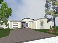
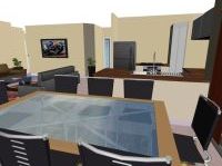
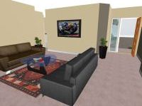
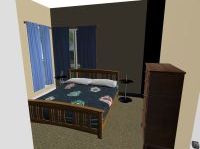
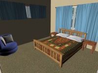
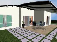
VizMAP has been contracted by a local real estate investment broker to create visualisations of a number of new homes and to place them in situ, as they will be constructed on a new development on central coastal Queensland. The investor will have the ability to choose their house then see it on their chosen property.
Click on these small resampled images to view the full screen images from the VizMAP website. Bear in mind that these are just screen dumps from a dynamic, interactive, 3D "flythrough".
If you would like more information on this project, or need your own similar project performed, let VizMAP know
|
| If you have a need to dynamically visualise your geographic data, let VizMAP know your requirements… |
Back to Top |
| 3-D Imaging Goes Ballistic |
from Wired News |
| WASHINGTON — A used bullet tells many tales. The grooves and striations it picks up as it blasts down a gun barrel can link weapons to crimes and help prosecutors put criminals behind bars. But the stories have always been two-dimensional. Until now.
New ballistics-imaging technology, developed by a Rockville, Maryland, engineering firm with funding from the Justice Department, lets forensic scientists capture a fired bullet’s distinctive markings in 3-D for the first time.
The technology, which was featured at the 2006 National Institute of Justice conference here Tuesday, works by projecting white light through a special microscope onto a bullet or its casing. The depth of the marks determines the intensity of the reflected light, which is recorded by a camera.
A computer then generates a 3-D image of, say, a Remington 9-mm slug or a Winchester .44-caliber Magnum round for researchers to pore over. Previously, forensic examiners were limited to flat photos of bullets and casings taken from different angles. But the wrong orientation of the photos can throw off the analysis: An examiner may end up comparing striations from different sides of the bullets. Not with the new technology.
"The 3-D representation is like a cross section," said Benjamin Bachrach, a vice president at Intelligent Automation, which developed the technology under grants from the Justice Department and the National Science Foundation. "The other way is an indirect representation."
The increase in microscopic precision could be a potential breakthrough for crime labs around the country. Already the technology has allowed scientists at the National Institute of Standards and Technology, or NIST, to create "golden bullets," clones of a standard slug that has been fired. With a golden bullet, crime labs can calibrate their imaging equipment to a single set of striations. This makes it easier to share data.
"You make reference materials for DNA — blood, hair. What about bullets?" said Susan Ballou, a program manager at NIST who showed off slides of her new ammo Tuesday. Ballou combined Bachrach’s 3-D system with a special stylus to make the golden bullets. "The stylus is like the diamond tip of an old record player," Ballou said. "It reads the grooves and surface."
|
| Read that full story here |
Back to Top |
| Whazzup Next – with 20/20 Foresight… |
| Check these sites for events to look out for in the Vis/Sim, GIS, LIS, Remote Sensing & Photogrammetry calendars… |
|
| |
Back to Top |
A Parting Gesture… |
| The New Wonder Drug |
From Grime |
| Do you have feelings of inadequacy? Do you suffer from shyness? Do you sometimes wish you were more assertive? If you answered yes to any of these questions, ask your doctor or pharmacist about TequilaR.
TequilaR is the safe, natural way to feel better and more confident about yourself and your actions. TequilaR can help ease you out of your shyness and let you tell the world that you’re ready and willing to do just about anything. You will notice the benefits of TequilaR almost immediately, and with a regimen of regular doses you can overcome any obstacles that prevent you from living the life you want to live. Shyness and awkwardness will be a thing of the past, and you will discover many talents you never knew you had. Stop hiding and start living, with TequilaR.
TequilaR may not be right for everyone. Women who are pregnant or nursing should not use TequilaR. However, women who wouldn’t mind nursing or becoming pregnant are encouraged to try it. Side effects may include dizziness, nausea, vomiting, incarceration, erotic lustfulness, loss of motor control, loss of clothing, loss of money, loss of virginity, delusions of grandeur, table dancing, headache, dehydration, dry mouth, and a desire to sing Karaoke and play all-night rounds of Strip Poker, Truth Or Dare, and Naked Twister.
|
 |
Back to Top |
|
Feel free to forward this to whomsoever you wish.
To e-mail the VirtualGeography Editor, click here.
To subscribe to VirtualGeography, click here.
To unsubscribe from VirtualGeography, click here. |
| |
…that’s all, folks! (for now).
|
|
VizMAP
- Bureau & Services Portfolio
- Contact Us
- News
- Gladstone Port Access Road nearly complete after VizMAP visualisation convinces Council
- TerraTools Exporter for Virtual Battlespace 2 (VBS2) Now Available – 23/3/9
- Updated interactive “Flash Map” of Advanced Mining Projects in Queensland by VizMAP to be distributed to delegates of Mining 2006
- VizMAP & E2E deliver workshop at Queensland Spatial Conference, Brisbane, Queensland – 17/7/8
- VizMAP creates “virtual trek” to the Everest Base Camp
- VizMAP creates virtual coal mine for central Kalimantan
- VizMAP develops interactive “Flash Map” of Advanced Mining Projects in Queensland
- VizMAP imagery of Virtual Surat Energy Province awarded image of the month by Image Society Inc.
- VizMAP Launched
- VizMAP launches FlyLG: computer based geospatial Visualisation tailored to Australian local government areas
- VizMAP presents at Australia Pacific Spatial Innovation Conference 08, Canberra, ACT – 19/11/8
- VizMAP presents at GITA 07, Brisbane, Queensland – 8/8/7
- VizMAP presents at GITA Seminar, Darwin, Northern Territory – October, 2006
- VizMAP presents at Queensland Spatial Conference 2008, Brisbane, Queensland – 18/7/8
- VizMAP presents at Surveying and Spatial Sciences Institute (SSSI) Meeting, Hervey Bay
- VizMAP Presents TerraTours® Visualization at World Energy Congress
- VizMAP presents to Darling Downs Interest Group in GIS and Remote Sensing (DIGGARS) Seminar, USQ, Toowoomba, Queensland – 8/11/7
- VizMAP presents to International Map Trade Association (IMTA), Surfer’s Paradise, Queensland – 2/11/7
- VizMAP presents to Queensland Spatial Industry Council (QSIC), Brisbane, Queensland – 22/11/7
- VizMAP writes for Position Magazine – “The 3D Industry” – April-May 2007, No 28
- VizMAP’s Virtual Surat Energy Province
- VirtualGeography Index
- VizMAP
|


